AutoNavi’s AI-Powered Omni-Strategy
 09/23 2026
 384
384

By Zhou Liying
Edited by Zhang Xiao
On September 10, AutoNavi unveiled its 2026 Street Exploration Rankings, marking the list’s first anniversary with a “full AI transformation.”
The most notable shift from a year ago is that the rankings are no longer solely based on a “foot-vote” sorting system. AI now discerns the significance of each store visit—whether it was a dedicated trip, a casual pass-by, a repeated visit, or a one-time purchase.
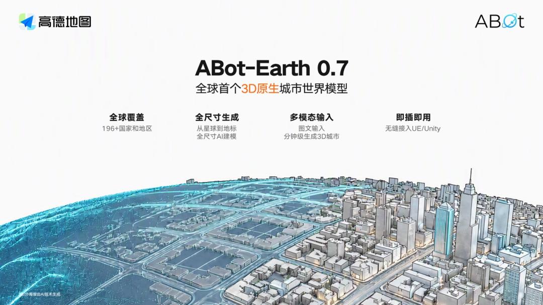
On the same day, AutoNavi also introduced its 3D native city world model, ABot-Earth 0.7, and officially announced Mercedes-Benz as the first automotive partner for the Street Exploration Rankings.
Image/AutoNavi Open Platform Official Weibo
Looking back over the past year, AutoNavi’s initiatives extend far beyond a single ranking—its spatial intelligence open platform, Yunrui Spatiotemporal Intelligence Platform, quadruped robot “Tutu,” and more—have demonstrated AI’s integration across C-end products, B-end platforms, software, and hardware, shaping nearly all of AutoNavi’s external narratives.
In January 2026, Alibaba Group CEO Wu Yongming, in his New Year’s letter, highlighted AutoNavi alongside Taobao Flash Shopping and the Qianwen App as one of the “beautifully executed major battles” of 2025. However, organizationally, AutoNavi remained categorized under “all other businesses,” rather than aligning with e-commerce or AI mainlines.
For AutoNavi, crafting its own AI narrative is both a technological upgrade and a strategic move to solidify its position within the group’s evolving ecosystem.
AutoNavi’s AI strategy unfolds along two primary axes: a vertical axis that deepens AI integration along the C-end user decision-making chain, and a horizontal axis that extends spatiotemporal intelligence as an open capability to the industry.
Yet, beyond these strategies, some longstanding challenges persist in AutoNavi’s new narrative.
01 Full AI Transformation: Evolution of the Street Exploration Rankings
A year ago, AutoNavi’s Street Exploration Rankings made waves by claiming to rely solely on users’ real navigation-to-store behavior, rejecting paid listings.
By disrupting the traditional trend of paid reviews in food rankings, the Street Exploration Rankings emerged as a game-changer in the local life sector, prompting competitors to upgrade their rules: Meituan’s Dianping enhanced its review requirements and introduced AI-reviewed evaluations; JD launched “True Rankings,” vowing “never to commercialize”; Baidu Maps, in collaboration with Meituan and Ctrip, introduced the “AI-Powered Top Picks.”
A year later, AutoNavi announced a full AI transformation of the Street Exploration Rankings, with upgrades centered on three key areas.
First, the algorithm has become more “sophisticated.” The new version leverages AI to assess the scoring weight of different store visit behaviors, significantly increasing the importance of “dedicated trips” and “multiple revisits.” As AutoNavi CEO Guo Ning stated, “Comments can be generated, but footsteps cannot be faked.”
Second, professional scores have been introduced. For categories like coffee, where expertise matters, evaluations from experts carry greater weight. Currently, over 15 million expert users participate in the “True Explorer Creator Program,” aiding 58 million people daily in making travel decisions.
Third, the rankings have expanded in both categories and coverage. The Top Rankings grew from three categories (food, hotels, attractions) to six, while the Local Gems Rankings expanded from 133 to 269 cities, reaching county-level areas. Additionally, the national BEST100 series rankings were introduced for the first time.
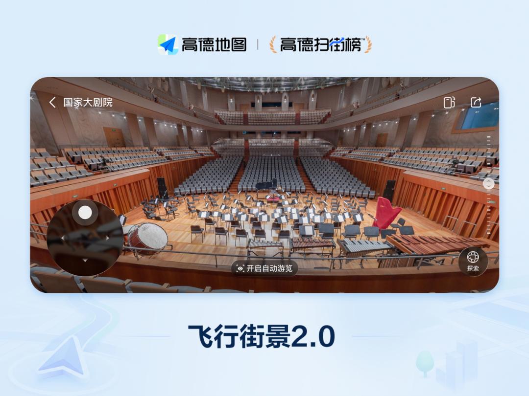
More notable than the rankings themselves is that the 2026 version transcends a mere list. Centered around the complete chain of “decision-making—departure—arrival,” AutoNavi simultaneously launched Flight Street View 2.0, Navigation Live, and Pitfall Avoidance Guide.
Image/AutoNavi Maps Official Weibo
Flight Street View 2.0 enables users to preview seat views and in-store layouts before departure; Navigation Live provides real-time traffic updates for efficient journey planning; the Pitfall Avoidance Guide checks itineraries across 15 dimensions, alerting users to closures, traffic jams, and scheduling conflicts.
Behind these innovations, AutoNavi has transformed the rankings from a “results page” into a “decision-making chain.” Flight Street View 2.0 addresses “whether to go,” Navigation Live tackles “how to get there,” and the Pitfall Avoidance Guide determines “whether it’s feasible.”
The implementation of this decision-making chain relies on three core capabilities:
- 3D representation, organizing road networks, buildings, and storefronts into an accessible and observable space;
- Dynamic perception, enabling spatial maps to reflect real-time traffic conditions—updating events like construction, lane closures, and temporary store closures to navigation routes instantly;
- Spatiotemporal reasoning, placing people and events into this dynamic space to predict journey encounters at specific times.
These capabilities are underpinned by AutoNavi’s vast data foundation—nearly 1 billion monthly active users, nearly 1 trillion daily calls to Beidou satellite positioning at peak, and tens of trillions of spatiotemporal samples accumulated from road networks, buildings, street views, and real navigation-to-store behaviors.
The 2026 Street Exploration Rankings represent AutoNavi’s productized implementation of spatial intelligence at the C-end, meeting massive user demands and serving as a key traffic entry point for AutoNavi to compete in the local life sector.
02 Spatial Intelligence: AutoNavi’s New Strategic Focus
The AI transformation of the Street Exploration Rankings is just one aspect of AutoNavi’s broader changes.
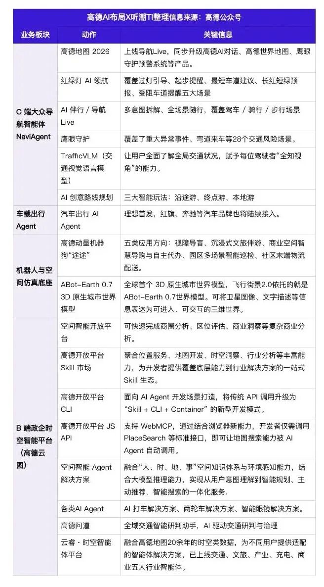
Today, AutoNavi has evolved beyond an electronic map into a spatial intelligence agent system spanning personal travel, in-car cabins, physical robots, and government-enterprise industry services, driving its transition from a “tool-based map” to a “spatial intelligence infrastructure.”
Image/Tingchao TI Self-Made
Vertically, the navigation agent NaviAgent for C-end users reconstructs the entire travel experience. NaviAgent is the core AI capability integrated into the AutoNavi Maps app.
On September 16, AutoNavi officially released AutoNavi Maps 2026. Building on the 2025 version, AutoNavi incrementally enhanced travel scenario capabilities.
AI-powered traffic light navigation went nationwide in 2025, covering five scenarios: guidance through lights, startup reminders, lane selection, long-red short-green forecasts, and obstructed lane alerts. AI companionship and Navigation Live enable multi-intent breakdowns, providing seamless services across driving, cycling, and walking. The Eagle Eye Protection System covers 28 types of traffic risks, such as oncoming vehicles at bends and sudden anomalies, continuously enhancing travel safety warnings.
Powered by the TrafficVLM traffic visual language model, AutoNavi provides drivers with a “god’s-eye view” of global traffic perception, breaking through the limitations of traditional navigation’s single-route prompts. Simultaneously, AI-powered creative route planning expands navigation from a commuting tool to a leisure travel scenario.
C-end capabilities further extend to automotive cabins, introducing the in-car travel agent. The automotive travel AI Agent debuted in Li Auto models, with Hongqi, Great Wall, BMW, GAC, and other automakers set to follow, bringing spatial intelligence capabilities into vehicle cabins for native in-car spatial intelligence interactions.
In the embodied intelligence sector, AutoNavi builds a robot and spatial simulation foundation. At the hardware level, it launched the quadruped robot dog “Tutu,” targeting five key application scenarios: guide dogs for the visually impaired, cultural tourism companions, commercial shopping guides, park inspections, and community last-mile logistics. The underlying ABot-Earth 0.7, the world’s first 3D native city world model, serves as a spatial simulation foundation, supporting Flight Street View 2.0 and transforming satellite imagery and text descriptions into accessible and interactive 3D digital cities.
Horizontally, AutoNavi packages and opens its over two decades of accumulated spatiotemporal capabilities, creating a B-end government-enterprise spatiotemporal intelligence platform, delivering standardized spatial intelligence agent solutions to government-enterprises, developers, and industry clients.
The Spatial Intelligence Open Platform lowers the threshold for spatiotemporal analysis, allowing users to complete complex commercial analyses like business district evaluations and location assessments through natural language queries. The AutoNavi Open Platform continuously iterates development tools, launching the Skill Market, CLI for agent scenarios, and JS API supporting WebMCP, upgrading traditional API calls to a Skill-driven new development paradigm, facilitating direct map capability calls by various AI agents. Based on this foundation, AutoNavi introduces an integrated spatial intelligence agent solution, leveraging “people, time, location, events” spatial knowledge to complete intent recognition, intelligent planning, active recommendations, and spatial searches.
Industry solutions continue to enrich: the AI taxi agent enables one-sentence taxi booking, supporting rapid access by various smart devices; the two-wheeler navigation solution completes HarmonyOS adaptation, launching electric bicycle and global motorcycle navigation, and integrating Eagle Eye Protection safety warnings; the global map foundation is upgraded, strengthening overseas location service capabilities; in collaboration with Rayneo Innovations, a smart glasses spatial solution is launched; the open platform mobile workstation is introduced, enabling full-process operational management on mobile devices.
For urban governance, AutoNavi Wendao serves as a comprehensive traffic intelligence assistant, empowering traffic management. The Yunrui Spatiotemporal Intelligence Platform, accumulating years of spatiotemporal assets, has deployed intelligent agents across five industries: transportation, cultural tourism, industry, charging, and commerce.
Overall, AutoNavi’s strategy transcends the traditional map vendor competition framework. C-end products like NaviAgent cater to personal travel, in-car agents penetrate the automotive industry, ABot-Earth and robot dogs explore virtual-physical spaces and embodied intelligence, while the B-end open platform turns spatial intelligence into a reusable infrastructure.
Actions are the surface; capabilities are the core. AutoNavi’s spatial intelligence is supported by multiple layers: collaborating with Tongyi to build a spatial intelligence large model cluster; self-developing the TrafficVLM traffic visual language model for minute-level traffic trend reasoning; the world’s first 3D native city world model ABot-Earth 0.7, significantly reducing 3D city scene generation costs; and relying on massive Beidou positioning and spatiotemporal samples to form a data closed loop.
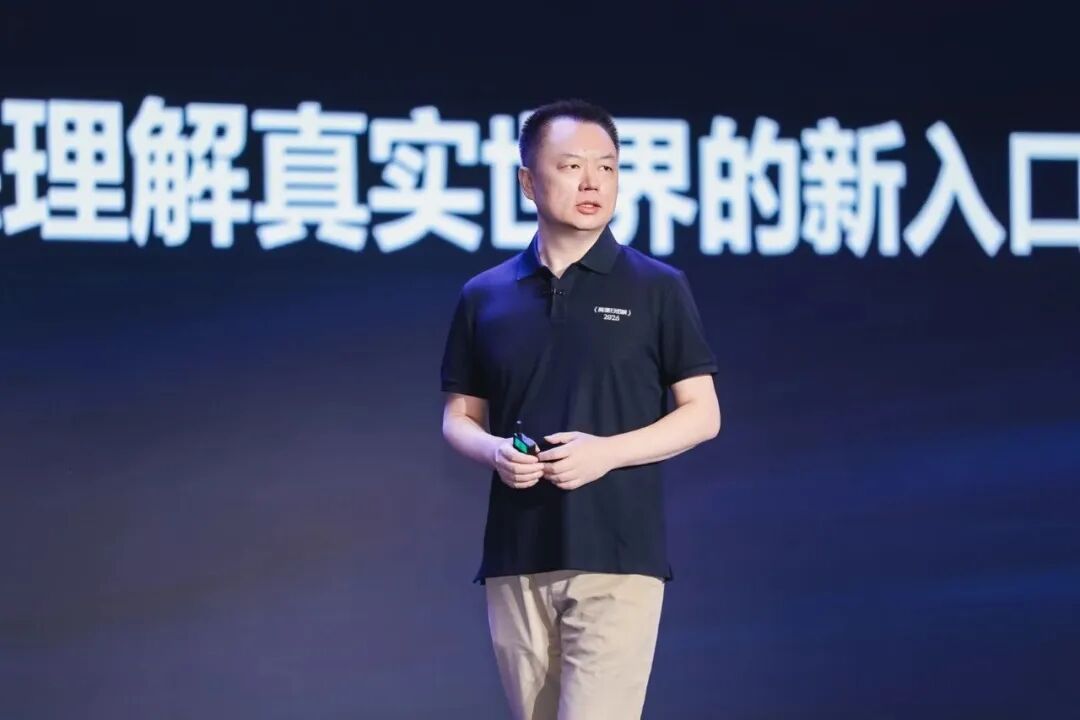
AutoNavi CEO Guo Ning believes, “Large models understand language; AutoNavi’s spatial intelligence understands the world.” Within the Alibaba ecosystem, Tongyi Qianwen handles cognition, while AutoNavi handles action. The next pressure test lies in achieving a commercialization closed loop.
Image/AutoNavi Open Platform Official Weibo
03 New Narrative, Old Challenges
AutoNavi’s AI strategy is ambitious, and its narrative is fresh, but it still needs to address an enduring question:
What is AutoNavi’s path to commercialization in the AI era?
A year ago, when the Street Exploration Rankings were released, market interpretations were consistent—Alibaba was serious about in-store services, even sparking rumors of “relaunching Koubei.”
But a year later, in-store services have receded into the background in AutoNavi’s overall presence. The group-buying business launched on September 20, 2025, in collaboration with Taobao, Alipay, and Ele.me, initially covered over 50 cities but has since seen limited follow-up. The industry norm remains users discovering restaurants on AutoNavi and then placing orders on Meituan or Douyin.
Reviewing C-end actions over the past year, few standout names emerge.
One Street Exploration Rankings, one AutoNavi Chauffeur launched in April 2026, and one AutoNavi Charter launched in July. All are extensions along the travel chain, with no cross-border transactions—compared to the high-profile B-end open platform and embodied intelligence, the C-end remains notably restrained.
This raises the first question: Can the product capabilities of the Street Exploration Rankings secure more in-store resources for AutoNavi, i.e., more users and merchants?
The positive evidence is solid. On the user side, the Street Exploration Rankings served 880 million users in a year, with navigation to listed merchants totaling 36.6 billion kilometers annually. In 2025, 5,115 small shops on the Local Gems Rankings saw a 424% year-on-year increase in orders, while Top Rankings merchants grew by 159%.
On the merchant side, 860,000 merchants voluntarily joined within 100 days of launch, with listed merchants experiencing a 330% month-on-month increase in orders. In January 2026, AutoNavi invested hundreds of millions in computing power to offer Flight Street View for free to 1 million merchants and launched a merchant services provider recruitment drive.
However, the flip side is equally clear: QuestMobile data shows that over 83% of AutoNavi’s nearly 1 billion monthly active users still perceive it primarily as a navigation and travel tool.
More critically, Guo Ning once promised that the Street Exploration Rankings would “never commercialize,” and ranking positions in this industry are among the most expensive advertising slots. While this promise builds trust, it also cuts off the most direct monetization path.
On one hand, there is the genuine customer traffic generated by "voting with one's feet"; on the other hand, there persists the ingrained belief that "traffic does not necessarily equate to customer retention." These two opposing forces continue to exert their influence. Further inquiry prompts us to consider: Does AutoNavi aspire to be a gateway or merely a utility? Whether deliberately or not, AutoNavi's actions over the past year have unmistakably leaned towards the latter.

Users primarily open AutoNavi for navigation and route-finding purposes, rather than to discover restaurants. This creates a significant disparity in user mindset compared to Dianping, where traffic is driven by active decision-making, and Douyin, where inspiration fuels user engagement.
As a result, a familiar pattern emerges: when aggregated taxi services reached daily order volumes in the tens of millions, they were constrained by a 9% cap on information service fees, resulting in meager profits and an inability to capture the full transactional closed loop, effectively serving as mere traffic intermediaries. Today, the local services sector appears to be following a similar trajectory—AutoNavi accrues usage time and data, but the transactional value is channeled elsewhere.
A closer examination of the revenue structure further elucidates the issue: In 2024, AutoNavi's revenue stood at approximately 12 billion yuan, with online advertising contributing 7.8 billion yuan (65%). However, advertising growth has decelerated from 28% in 2022 to 12%. Following the complete elimination of splash screen ads in June 2026, the traditional revenue stream is dwindling, while new monetization avenues have yet to emerge as significant contributors.
Thus, while AutoNavi's AI transformation offers a captivating new narrative, age-old challenges persist: how to transition from a tool-centric mindset to a consumption-oriented one, how to convert traffic into sustained customer engagement, and how to translate technological investments into tangible revenue.
Nevertheless, AutoNavi's AI strategy continues to evolve and expand, at least affording the company more time to "address" these pressing questions.
-
![]()
The 'Original Data Sin' in the AI Industry: Unraveling the Zhipu ZCode Controversy
-
![]()
Li Yanhong’s Good Looks Can’t Rescue Baidu AI’s Struggles
-
![]()
JAC Motors: Is It the New 'Star Player' in the Eyes of Investors?
-
![]()
Hangzhou Beckons! Xinguang Optoelectronics Unveils 100 Million Yuan Investment for Precision Measurement Subsidiary
-
![]()
Largan Precision Secures Land for NT$8 Billion! What Are the Chances of Winning the CPO Bet?
-
![]()
Not Just 'Talking the Talk': AutoNavi Enhances AI's Understanding of the Physical World
-
![]()
Exclusive Interview with Xiong Guanhao from Sunny Optical: Reconstructing the Value of Light with 'Optics + AI'
-
![]()
More Than 50 Crashes: A Chinese Farmer Takes Flying Cars to the Emirates Palace in Abu Dhabi