How do autonomous vehicles identify suspended objects?
 04/02 2026
 625
625
I wonder if you have ever encountered scenarios like trees bent by the wind, streetlight poles slanting across the road, or clusters of dense branches hanging low from the roadside. For human drivers, it's easy to tell at a glance whether these objects will block the way. However, for autonomous vehicles that rely entirely on sensors, identifying suspended objects in space is an extremely complex process.
These objects are not directly connected to the ground, or their main parts are at the edge of the sensor's routine scanning range (I keep this pin yin as the accurate term should be decided in specific context), making them easily mistaken by algorithms as background noise or false alarms that can be safely passed. So, how do autonomous vehicles identify suspended objects?
Obstacle Avoidance Principle of LiDAR
As the 'depth eyes' of autonomous vehicles, LiDAR is the most capable tool for identifying suspended objects. By continuously emitting laser pulses and calculating the time it takes for these pulses to bounce back after hitting an object, it can accurately measure the distance between the object and the vehicle.
When thousands of laser points hit the surrounding environment, the system obtains a dense 'point cloud map.' Unlike flat ordinary photos, a point cloud map is three-dimensional, recording the exact coordinates of each point in space, including height information. This means that when lasers hit branches spanning the road or slanted light poles, the system can immediately perceive the geometric outlines of these objects and their heights above the ground.
During actual driving, the first issue the system must address is 'how to set the ground aside.' The data collected by LiDAR is enormous, with the vast majority being flat road surfaces. To make suspended objects visible, the system runs a 'ground filtering' algorithm.
This algorithm analyzes the vertical height differences in the point cloud, removing point clouds that match ground characteristics. What remains are obstacles protruding above the ground. For irregularly shaped objects like branches, the system uses multi-frame point cloud superposition technology. By capturing the vehicle's position changes during travel, it takes 'photos' of the object from multiple angles, piecing together its accurate shape and volume in the air.
Besides shape, LiDAR can also detect 'reflection intensity.' Different materials reflect lasers with varying efficiencies. Streetlight poles, made of metal, have a very high and stable reflectivity. In contrast, leaves, containing moisture and having a rough surface, reflect signals that are relatively chaotic and weak.
By analyzing differences in reflection intensity, the autonomous system can initially determine whether the obstacle ahead is an untouchable metal pole or soft leaves that can be lightly brushed against. For extremely thin branches, although a single laser point may struggle to capture a complete outline, special line-fitting algorithms like the Random Sample Consensus (RANSAC) method enable the system to identify linear structures with certain diameters and lengths from scattered interference points, thereby predicting tree extensions.
Of course, LiDAR has its limitations. As the detection distance increases, laser points become sparser. A distant streetlight pole may only be scanned by a single laser point, making judgment difficult.
However, autonomous vehicles typically mount LiDAR at the highest point on the roof, ensuring full coverage of the space above the vehicle's front through a downward-tilted scanning angle.
From this bird's-eye view, the vehicle can detect potential height obstacles above through sparse point clouds hundreds of meters away before entering dangerous areas.
Obstacle Avoidance Principle of Millimeter-Wave Radar
Millimeter-wave radar detects an object's speed and distance by emitting radio waves and is almost unaffected by heavy rain, thick fog, or darkness. However, traditional millimeter-wave radar lacks 'elevation angle' resolution.
Simply put, it can sense something ahead but struggles to distinguish whether it's a broken-down car on the road or a traffic sign suspended in mid-air.
This lack of height perception has caused many 'phantom braking' incidents in autonomous systems, where the car suddenly slams on the brakes at an empty road or a high sign.
To overcome this challenge, 4D imaging radar technology has emerged. The '4D' refers to the addition of a fourth dimension—height—to the original distance, speed, and azimuth angle. By introducing more antenna arrays and advanced digital signal processing algorithms, 4D imaging radar can generate point clouds with vertical resolution like LiDAR.
When a vehicle approaches a slanted streetlight or a low overpass, 4D radar can clearly measure the clearance height from the object's bottom to the ground. If this height exceeds the vehicle's height plus a safety margin, the decision-making system knows it can pass safely, avoiding unnecessary panic braking.
4D imaging radar is also keenly observant of an object's motion state. Through the micro-Doppler effect, it can capture extremely subtle vibrations on an object's surface. The swaying of branches in the wind or the slight resonance of utility poles in the airflow have unique manifestations in radar signals.
In contrast, stationary vehicles parked by the roadside or obstacles fixed to the ground exhibit entirely different signal characteristics. By leveraging these subtle physical traits, the system can distinguish suspended natural scenery from man-made structures, greatly enhancing recognition accuracy.
Additionally, since radio waves reflect extremely strongly off metal objects but weakly off plant leaves, the radar system can assist in judging an object's hardness by calculating echo energy intensity. When a slanted metal light pole appears in the path, the radar receives a very strong and concentrated feedback signal. In contrast, when it encounters branches, the signal appears fragmented and dispersed.
This sensing of an object's 'texture' provides an extra layer of safety redundancy for autonomous vehicles in complex urban scenarios. Even if LiDAR fails due to heavy fog, 4D imaging radar can still hold the last line of defense, ensuring the vehicle doesn't crash into hard objects hanging above.
Can Occupancy Grid Technology Help Vehicles Understand Complex Shapes?
Besides LiDAR and millimeter-wave radar, autonomous vehicles are equipped with numerous cameras. Traditional visual recognition methods mainly rely on 'object detection,' which involves drawing boxes around objects in photos.
However, this box-drawing method fails when dealing with suspended objects. A weeping willow or an irregularly slanted utility pole is difficult to accurately describe in space using a neat box.
To more authentically reconstruct the world, a technology called 'occupancy grid prediction' or 'occupancy networks' is becoming mainstream.
This technology no longer focuses on 'what the object is called.' Instead, it divides the space around the vehicle into tens of thousands of tiny cubic grids, known as 'voxels.' The system uses a deep learning model to predict whether each grid is occupied by an object or empty.
For suspended objects, this method is tailor-made. Even for a branch with an extremely complex shape, half-hanging and half-suspended, the system can calculate which grids it occupies in 3D space through multi-angle images captured by cameras.
In this way, the vehicle's path planner will find a path composed entirely of 'empty grids,' cleverly navigating around the suspended object from below or the side.
Under the occupancy grid system, the visual system can capture extremely subtle semantic information. By analyzing image pixels one by one, cameras can identify which grids belong to 'vegetation' and which to 'traffic facilities.'
When facing a slanted streetlight, the visual system can recognize the texture and structural features of its metal top, marking it as an impassable rigid obstacle. When facing branches, if the occupancy grid shows a very sparse distribution of these grids and the semantic label indicates 'leaves,' the system may lower their risk weight, deeming slight contact unlikely to cause serious consequences.
The visual system can also utilize the 'parallax' principle to enhance height perception. Just as humans use two eyes to judge distance, autonomous vehicles can calculate the positional deviation of the same object in different images through multiple cameras at different positions.
For suspended objects, this parallax change is very noticeable. When the vehicle moves, suspended branches close by shift much faster in the image than distant backgrounds.
Through this dynamic visual information, the system can continuously update the object's position and height in 3D space. This ability is particularly crucial in areas lacking high-precision maps, enabling the vehicle to make autonomous judgments while 'seeing and thinking on the move.'
How Should Vehicles Make Decisions When Facing Obstacles of Different Materials?
Identifying objects is just the first step; the harder part is deciding 'what to do.' The decision-making and planning system must grade the threat level of suspended objects based on all information collected by sensors. This involves a core logic: distinguishing between rigid and flexible objects.
A slanted streetlight pole is a typical rigid obstacle. Its diameter, material, and position determine that the vehicle must absolutely avoid contact. Branches, however, present a complex situation. They may be soft twigs or thick, dry branches capable of smashing the windshield.
To make accurate judgments, the system employs a 'multi-sensor fusion' mechanism.
Imagine a scenario where cameras in front of the vehicle identify some green leaves, LiDAR measures these leaves to be about two meters above the ground, and millimeter-wave radar detects almost no strong reflection signals. Combining this information, the system concludes that these are likely low-hanging soft branches, posing no substantial threat to driving safety.
However, if both LiDAR and radar detect strong signals at that height simultaneously, and the visual system identifies a gray, metallic texture, the system immediately classifies it as a dangerous object and sets it as an absolute no-go zone in path planning.
For bushy, partially obscured objects, the system also uses specific algorithms to assess their 'penetrability.' In extreme off-road or rural conditions, the vehicle may have to pass through dense vegetation.
At this point, the system analyzes the penetration rate of LiDAR echoes. If lasers easily pass through the object to hit the background behind, it indicates the object is very sparse. If lasers are completely blocked, it means the object is very solid. This judgment based on physical properties enables the vehicle to conduct not just simple obstacle avoidance but complex environmental risk assessments when making decisions.
-- END --
-
![]()
Model Giant Jieyue Xingchen Steps into Smartphone Arena: A Strategic Alliance with Huaqin Technology
-
![]()
Big Model Firm Dives into Phone Market: StepFun and Wingtech Forge a ‘Dynamic Duo’
-
![]()
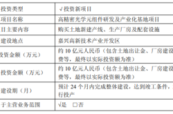
Zhongrun Optics Makes a Bold Move with 1 Billion Yuan Investment: Is a Turning Point on the Horizon for the Precision Optics Industry?
-
![]()
Deploy CLBO Crystals and YIG Single Crystals! Erythritol Leader Invests 30 Million in Youwei Optoelectronics
-
CXMT’s July 16 Subscription: Leading Domestic Memory Manufacturer—What’s the Earning Potential per Lot?
-
![]()
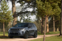
Rhythm Discrepancy and Premium Value Erosion: Foreign Luxury Brands Must Re-evaluate Their China Strategy
-
![]()
Half-Year, 1 Billion Yuan Financing, 7 Billion Yuan Valuation: A New Dark Horse Emerges in the Embodied AI Sector
-
![]()
Strong Rebound for Tech Stocks in Hong Kong Stock Market: Is It Time to Bottom-Fish?